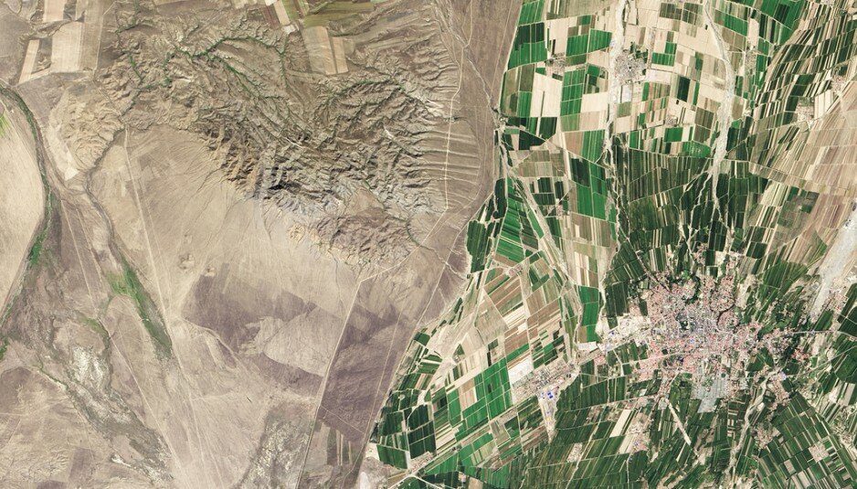
The satellite image of the Kazakh-Chinese border emphasizes different approaches applied to agriculture and land resources use in the two countries, according to Metkere.com.
The photo made from the Landsat-8 satellite back in September 2013 features Balkhash lake basin in East Kazakhstan and Tacheng province in the North-West of China. On the Kazakh side the photo mostly showcases deserts, with the successes of the Chinese irrigation industry being noticeable from the outer space, according to Ilya Kabanov, a blogger with Metkere.com.
According to the author, arable lands account for 11.62% of the China’s territory. To sustain the huge population, all the available arable land is carefully cultivated.
“The dark green fields bordering on arid landscapes is a result of effective irrigation efforts. Back in 2006 about 65% of fresh water in China was used for irrigation purposes, enabling to cater to 629 380 square kilometers under crops”, according to Ilya Kabanov.
The current situation in Kazakhstan is drastically different. “Though the agriculture is believed to be an important industry, areas under crops in East Kazakhstan are not very significant. Irrigation techniques are only available in a territory of 20 660 square kilometers, with the rest of the territory being sustained only by rainwater. Therefore the agriculture landscapes are pretty similar to surrounding wild wasteland”, Kabanov sums up.
Source: TengriNews
33,249 total views, 60 views today


Aug 21, 2014 - 12:28 PM
We got to be wiser in terms of use of our resources